
As the governance of super-large cities evolves towards refinement and intelligence, quantum city construction centered on spatial intelligence has become a key direction for reshaping the urban governance paradigm and enhancing governance efficiency.
In the early stage, the “Yunyu Star Sky Large Model” jointly developed by SenseTime’s large-scale device and the Shanghai Municipal Planning and Resources Bureau was fully upgraded. This enhanced the professional space reasoning and complex task execution capabilities, enabling the model to evolve from simply “answering questions” to being able to “perform tasks”.
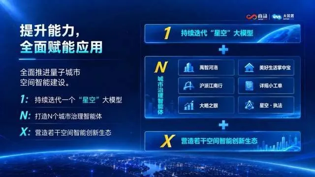
Based on the newly upgraded “Yunyu Star Sky Large Model”, the Shanghai Municipal Planning and Resources Bureau has centrally released the first batch of government smart agents for quantum cities, including the “Yu Zhi He Luo” flood control smart agent, the “Good Life Pocket Tool” smart agent, and the “Shanghai Style Jiangnan Travel” smart agent. Among them, the three intelligent agents—“Yu Zhi He Luo”, “Great Overview Eye”, and “Detailed Work Order”—were developed and delivered by the SenseTime Large Model Team. They take on the roles of “digital employees” responsible for flood control scheduling, spatial insight, and planning updates, thereby further integrating the capabilities of large models into urban governance processes, and exploring new practices in AI-driven spatial governance for megacities.
Space knowledge and reasoning capabilities are further evolved, enabling large models to truly “understand space”
As the first industry-based large model in the field of planning resources across the country, “Yunyu Starry Sky Large Model” serves as the intelligent foundation and central hub of the quantum city large model system. It aggregates industry knowledge, spatial data, and business rules from planning and construction, as well as urban governance, and has formed 13,000 high-quality Q&A pairs and 1.5 billion Tokens of text data, covering major professional areas such as planning design, surveying and mapping, and natural resources.
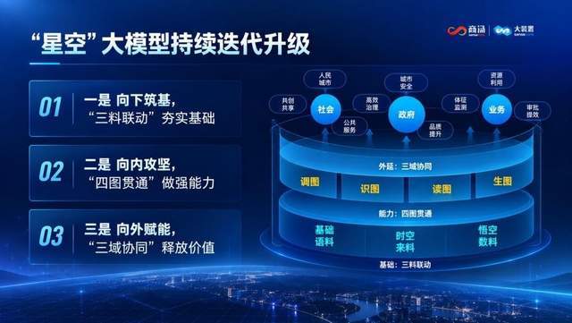
This upgrade focuses on two dimensions: knowledge ability and reasoning ability, further enhancing the model’s understanding of urban space and its relationships.
- In terms of knowledge capabilities, using OLA (object-relation-action) as a unified organizational framework, we promote the integration of language data, material data, and numerical data.Among these, the data encompasses industry knowledge such as policies and regulations, technical standards, business processes, and expert experience. The data also maps the positions and relationships of urban elements like buildings, plots of land, and roads using spatial units. It primarily integrates multi-source spatio-temporal data from current conditions, planning, monitoring, and remote sensing. Through unified object coding, spatial indexing, and temporal relationships, it enables the interconnection of text, graphics, vectors, images, videos, 3D models, and real-time perception data, thereby strengthening the knowledge network and spatial framework of the model.
- In terms of reasoning ability, the focus is on improving “four aspects of drawing: adjusting maps, recognizing maps, reading maps, and generating maps,” to establish a complete capability chain from data invocation, spatial identification, professional judgment to result generation. This will enable large models to have professional spatial reasoning capabilities—they can not only “see” the drawings, but also “understand” spatial relationships.
From “model capabilities” to “task execution”, building a universal foundation for the implementation of agents
Based on the newly upgraded “Yunyu Space Large Model”, supported by high-quality spatio-temporal data, and using the intelligent agent development and operation platform as a carrier, SenseTime’s large device has created an intelligent agent general platform capability foundation that connects the “model scheduling – information supply – task execution – capability accumulation” end-to-end task chain, and deeply integrates spatial intelligence capabilities into the entire process of planning and urban governance operations.
Using a unified model service to achieve “layered flexible scheduling”. Based on task complexity, through model routing and task decomposition mechanisms, different models and specialized algorithms can be flexibly invoked. For example, high-frequency queries, information extraction, and basic validation tasks are processed quickly by lightweight models; complex spatial reasoning, scenario analysis, and task planning tasks are handled by the core large model.
With data and knowledge foundations, provide “precise information”. Based on the integration of language data, material data, and numerical data, a spatial-temporal data resource system covering knowledge bases, rule bases, case bases, and indicator bases is established. This enables the intelligent agent to accurately retrieve and use data according to objects, time, space, and business relationships, providing reliable data and knowledge for task execution.
Using the agent development and operation platform, it supports “task execution”. Relying on the agent development and operation platform, it integrates capabilities such as task planning, process scheduling, context and memory management, model invocation, tool invocation, multi-agent collaboration, and operation monitoring. It breaks down complex business processes into a series of executable tasks, and further completes data querying, spatial calculations, model deduction, rule judgment, result generation, and manual confirmation.
At the same time, SenseTime’s large-scale system also encapsulates common capabilities such as professional Q&A, image retrieval, element recognition, spatial relationship understanding, and report generation into reusable industry skill components. This allows different intelligent agents to combine these components as needed, reducing duplicate development efforts, and enabling the capabilities developed for a single project to be reused and accumulated.
At the core scenarios of urban governance, enable digital employees to become effective on the job
If large model upgrades address the issue of “understanding space,” then intelligent agents solve the problem of “how to use spatial intelligence to solve real-world problems.” Taking the three intelligent agents developed and delivered by SenseTime’s Large Devices—“Yu Zhi He Luo, Da Lü Zhi Yan, and Xiang Gui Xiao Gong Dan”—as examples, they are designed for scenarios such as flood control scheduling, spatial insight, and planning updates, transforming spatial intelligence into practical governance practices.
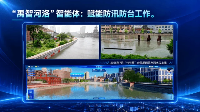
“Yu Zhi He Luo” enables scheduling to stay ahead of the wind and rain. For flood control safety in the Suzhou River Basin, this intelligent system can comprehensively use data such as weather, water levels, and drainage flow rates to perform precise and intelligent scheduling by region and time. Through 48 hours or even 2 hours of early analysis and real-time scheduling simulations, an intelligent dynamic balance is achieved across the “river network—pipe network—neighborhood” space. After implementation, the efficiency of spatial intelligent computing, dynamic simulation, and intelligent scheduling has increased by 65%, 70%, and 80%, respectively.
"Great View" enables the monitoring of urban indicators at any time. As a smart insight window for urban space, "Great View" aggregates high-quality spatiotemporal data from 18 years of status, planning, ownership, and approvals, and creates a digital twin map covering all elements such as construction, farming, forests, water, and wetlands. For urban decision-makers and administrators, they can instantly grasp changes and distributions in a city’s spatial resources—such as whether industrial land is idle or the ecological conditions in specific areas—and can quickly query and analyze these issues using natural language. Data analysis indicators that used to take months to develop can now be quickly customized in just a few minutes through natural language, transforming urban space insights from “customized development” to “personalized for each individual.”
"Detailed Work Orders" enable planning management to be handled while discussing. Focusing on the management needs of urban renewal in the era of existing assets, we create an intelligent collaborative assistant that allows enterprise requests to be processed intelligently with one click, gathers collective wisdom from a creative platform, and enables quick review of planning base maps—promoting high-quality urban renewal.
Based on the FDE model, a replicable scenario co-creation model is formed
Urban governance has highly complex operational characteristics. The real implementation of intelligent agents is not simply connecting a large model to the business system, but requires continuous solutions to a series of issues such as “how to define business problems, how to organize data, how to accumulate knowledge, how to validate models, and how to iterate outcomes.”
In this project, Shangtang’s large-scale device relies on the FDE scenario co-creation mechanism. Business experts and R&D teams are organized to work deeply at the front line of business. Starting from real business needs, they jointly clarify business processes, define problem criteria, and verify application effects, forming a closed loop of “problem definition—data and knowledge preparation—AI development—business verification—feedback and iteration”.
The value of this mechanism lies in the fact that what is delivered is not just an agent, but a set of continuously iterative industry intelligence capabilities. As business scenarios expand, the data, knowledge, tools, and industry skills that are accumulated can be further reused for other agents, achieving a transition from “single project construction” to “reuse of industry capabilities”.
In the future, SenseTime’s large-scale system will work together with the Shanghai Municipal Planning and Resources Bureau to promote the continuous evolution of the Yunyu Starry Sky large model. On one hand, it will progress from an industry-level large model to a city-wide macro-world model, fully and accurately reflecting the macro-operating patterns of cities. On the other hand, it will evolve from a single intelligent agent to a group of urban intelligent agents working together, supporting the joint analysis and coordinated handling of complex urban issues. At the same time, we will further explore the “open-source city” ecosystem, working in collaboration with industry partners in planning and design, surveying and mapping, urban governance, software development, and data services, to jointly build a replicable and scalable model for urban intelligence construction.
This article is provided by SenseTime Technology, and Qbit has been authorized to reproduce it. The views belong to the original author.